Hardingham / Low Street / Old Hall context
Place research page generated from the structured place spine and the companion place markdown.
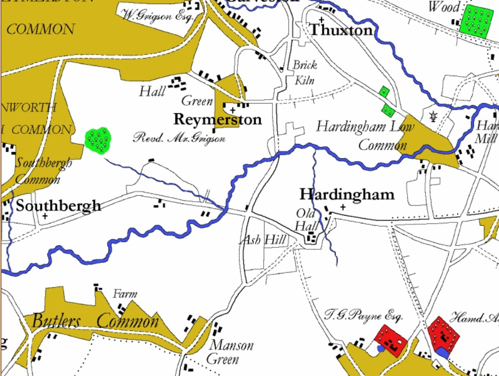
Hardingham parish in central Norfolk, including the Swathing / Swathings / Low Street place-memory and the Manor of Gurneys & Swathing. The parish history places Old Hall opposite St George's Church and treats the church/Old Hall area as the early village core.
Linked ancestors
- G18 William Gurney V landholding / property reference
- G23 Edmund Gournay landholding / property reference
- G23 Edmund Gournay individual geography
- G24 John de Gournay IV landholding / property reference
- G25 John de Gournay III landholding / property reference
- G26 Sir William de Gournay III, Knt. landholding / property reference
- G27 Sir John de Gournay I, Knt. landholding / property reference
- G28 Sir William de Gournay II, Knt. landholding / property reference
- G29 Sir Matthew de Gournay, Knt. landholding / property reference
- G29 Sir Matthew de Gournay, Knt. individual geography
- G30 Sir William de Gournay I, Knt. landholding / property reference
- G30 Sir William de Gournay I, Knt. individual geography
- G31 Walter de Gournay landholding / property reference
- G23 Sir John Gurney, Knt. (d.1408) — Related Related landholding / property reference
- G23 Sir John Gurney, Knt. (d.1408) — Related Related individual geography
Village and civil parish in central Norfolk, England, about 12 miles west of Norwich. Coordinates: 52.5708, 0.8508.
Hardingham matters here as a layered place: the modern parish, the remembered outlier of Swathing or Swathings, the later hamlet name Low Street, and the Manor of Gurneys & Swathing all sit in the same local historical frame. The Hardingham parish history says Hardingham itself is not named in Domesday, while Flockthorpe is. It identifies the Domesday outlier “Mantatestone” with modern Manson Green, identifies “Swathing” with modern Low Street, and says that between 1066 and 1210 there were two lordships in the local frame: the De Camois manor of Flockthorpe and the Manor of Gurneys & Swathing. In 1210, Flockthorpe became Hardingham, and the page explains “ham” as a Saxon word for a small village or settlement.[1]
Location of Swathings manor, held for centuries by the junior Gournay line. Together with Harpley, it forms one of the two principal Norfolk manorial anchors of the branch before West Barsham rose to prominence.
Why this place matters structurally
Hardingham is one of the deepest continuity records in the Norfolk set. In project terms it helps show the junior line as a durable territorial family rather than a pedigree assembled from disconnected names. If Harpley expresses the family’s long manorial identity in north-west Norfolk, Hardingham expresses its equally old centre in mid-Norfolk. [DG-I]
The later structured links to the Tudor family also matter here. Henry Gurney’s research companion identifies Hardingham (Swathings) among the manors still associated with the family in 1572. So Hardingham is not only an early junior-line record under Walter, William, and Matthew; it also helps connect the medieval line to the later literary and gentry world of Henry G15. [Henry G15 companion]
Gurney ancestors holding here
| Ancestor | Gen | Period | Notes |
|---|---|---|---|
| Walter de Gournay | G31 | b. 1090×1104 – d. 1150×1166 | Attribution to Walter himself uncertain — Daniel Gurney: “It does not appear whether Walter de Gournay held the manors of Swathings and Hingham Gurney’s, possessed by his descendants” (Record Part II p. 288); the manors are first securely documented with his son William |
| William de Gournay I | G30 | fl. c. 1150–1180 | Lord of Swathings manor |
| Sir Matthew de Gournay | G29 | fl. c. 1180–1220 | Gave tithes of Hardingham to the parish church |
| William de Gournay II | G28 | fl. c. 1210–1250 | |
| Sir John de Gournay I | G27 | fl. c. 1240–1280 | |
| Sir William de Gournay III | G26 | fl. c. 1260–1300 | |
| John de Gournay III | G25 | fl. c. 1300–1353 | |
| John de Gournay IV | G24 | fl. c. 1330–1370 | |
| Edmund Gournay | G23 | d. 1387 | |
| Henry Gurney | G15 | d. 1615/16 | Manor still associated with the family in 1572 |
Primary-source hooks
- Harleian MSS. 970 (Vitis Calthorpiana) — Matthew’s tithe grant to the Hardingham church.
- Plea: Matthew v. Gilbert de Runhall (DG-I Appendix LIII) — key legal record for the early junior line.
- Blomefield’s Hardingham entry for fuller Swathings descent.
Interpretive note
Hardingham is especially useful because it bridges the early junior-line proof period and the later Tudor period. That is a stronger role than the current short structured description can carry by itself, so the narrative file should continue to preserve this longer continuity.
Swathing, Low Street, and the Gurneys & Swathings manor
The Hardingham tradition that Swathing survived as a local place-name is important because it ties the medieval Swathings evidence to modern settlement geography. That makes Swathing/Swathings more than a loose alias. In the local-history layer, it is a remembered outlier or settlement name now associated with Low Street; in the manorial layer, it is paired with the Gurney name as the Manor of Gurneys & Swathing; and in the medieval evidence summarized by Blomefield, it appears in land, tenure, free-warren, mill, fold-course, pasture, and life-estate contexts tied to the Gurney descent.[1][2]
White’s 1845 directory gives a useful nineteenth-century corroboration of the same local geography: Hardingham was a parish of scattered houses including the hamlets of Flockthorpe and Low Street, and it had “the manors of Camois, Gurneys, and Swathings.”[3]
Blomefield supplies the older manorial descent behind that local memory. Matthew de Gurnay demanded a carucate of land in Hardingham, Swathing, and Runhale in 8 King John, which William his father had held in Henry II’s reign. Hugh de Gorney granted Robert the Burgundian the manor of Swathing in Hardingham with the church and appurtenances for 20s sterling per year and the gift of one horse, the grant being made at Ferretre before Hugh’s men or tenants. Blomefield explicitly connects this to Gourney in Normandy, “from which they took their name.”[2]
The same descent records the tenure becoming locally concrete: in 52 Henry III William de Swathyng held of John de Gurney a messuage, 54 acres of land, 3 acres of wood, free grinding at John’s mill called Ravensholm, and associated fold-course and pasture rights. William de Gurnay claimed free warren in 15 Edward I; John Gurney was lord in 9 Edward II; and in 43 Edward III the manor was granted for life to Sir Hamon Felton with remainder to Edmund Gournay, Catherine his wife, and John their son in tail.[2]
Blomefield carries the descent on past the Felton life-grant. In 17 Richard II Edmund Swathing and Catherine his wife conveyed the manor of Swathing by fine to Ralph Bateman (with reservations); in the 3rd of Henry IV John Gurney was lord; and at the end of the Gurney chapter stands a deliberate act of recovery: Thomas Gournay II (G20), who died in 1471, bought Swathings back from Catherine Sturmer late in life — re-acquiring the manor his ancestors had held since the twelfth century, roughly three centuries after William de Gournay I first appears at Swathings and a generation or two after the tenure had passed out of the family (by 1450 “writings … of Gorney” relating to the Swathings orbit lay among Sir John Fastolf’s Hellesdon muniments). His will then let it go on his own terms: the register’s ultima voluntas (the “last will” disposing of lands) directs the “lands called Swathings in Hardingham lately bought” to be sold by his executors for the performance of the will and pious uses for his soul and his wife Margaret’s, while Blomefield’s summary says Swathings and the Norwich tenements were “to be sold to William his son for 80 marks” — a real divergence between the register text as read and the printed summary, left open until a final Latin edition of the crowded closing clauses.[2][4] After the sale the manor passed to the Thwaytes family. Blomefield also records, out of chronological sequence in the printed descent, that “William Gourney, Esq. son of Thomas, and his wife, daughter of Sir William Calthorp, held the manor of Swathing and Hardingham in the 2d of Richard II”; the regnal date sits inconsistently with the surrounding entries and most plausibly telescopes the documented mid-fifteenth-century marriage of William Gurney IV (G19) to Anne Calthorpe rather than evidencing a distinct fourteenth-century Gurney–Calthorpe match. The Swathing rents Thomas Gournay had bought from Catherine Sturmer are the same bequest itemised in his 1469/70 West Barsham will.[2][5]
For the place file, this should be treated as a layered place-memory sequence: Swathing was not just a surname-like label in a pedigree; it was remembered locally as a Hardingham outlier, later Low Street, and as a manor paired with Gurneys in both local history and White’s directory.
Daniel Gurney’s second part gives the broader medieval-geography claim directly: “the manor of Swathings was a Saxon parish, which is now divided; it consisted of part of Hardingham, Letton, and Cranworth. Runhall was a hamlet or beruite to it.” This makes Swathings a cross-parish historical geography, not merely a Hardingham hamlet label.[6]
The church/Old Hall setting gives the place a later built-landscape anchor. The parish history places Old Hall opposite St George’s Church, considers it late sixteenth century, and says the village must originally have formed around that area. The Faden map extract adds visual context by showing Hardingham, Old Hall, Manson Green, Hardingham Low Common, the church symbol, roads, and watercourses in the late eighteenth-century landscape.[1][7]
Farrer on Swathings in the senior Gurnay fee
Farrer places Swathings within the senior Gurnay fee after the 1203 seizure of Hugh de Gurnay’s lands. After naming Cantley and Caister among the lands committed to John Marshal, he adds that other land in Norfolk of this fee lay in Swathings, where Hugh de Gurnay II had given a manor to Robert de Burgeinuin and Hugh son of the donor confirmed it to Hugh son of Robert de Burguinuin. He also records a grant by Hugh de Gurnay II and Milicent his wife of five librates of land in Bledlow, witnessed by William de Merlo, Oliver de Age, Hodus de Brumustier, Hugh de Burgeinuin, and others.[8]
This does not displace the later junior-branch Hardingham/Swathings evidence. It adds an earlier senior-line fee layer showing why Swathings belongs in the broader Gurnay place network before the better documented G27-G23 Norfolk descent.
Swathings held of Bardolf “as parcel of the barony of Gurnay” (Thomas Bardolf IPM, 1329)
The inquisition post mortem of Thomas Bardolf, taken 1329 and calendared as no. 243 of the Calendar of Inquisitions Post Mortem, vol. 7, is the primary printed-calendar record that ties the junior line’s Swathings tenure to the old senior Gournay barony. Within the same extent that returns Bardolf’s Norfolk caput manors, the manor of “Shathingge” (Swathings) is returned as “held by John de Gurnay by service of a knight’s fee” — the junior-line John holding Swathings of Bardolf.[9]
The surrounding extent items show why that matters. Bardolf’s manors of Caister by Great Yarmouth, Cantley, and Winburgh were re-settled on Thomas Bardolf and Agnes his wife in 7 Edward II (1313/14), by a fine levied through the feoffees “John de Gurnay and John de Halughton,” and are returned as held in chief “as parcel of the barony of Gurnay.” That barony is the forfeited senior-line Gournay honour, which had descended to the Bardolfs through Juliana de Gournay (heir of the last senior-line Hugh, wife of William Bardolf of Wormegay). So the junior John de Gurnay appears here twice over: as the trusted feoffee who re-settled the Bardolfs’ Gournay-barony manors in 1313/14, and as tenant of Swathings held of Bardolf by knight service.[9]
This is the primary-calendar confirmation of the tenure chain that Daniel Gurney’s Supplement (Note 115) had recorded only from a later Norfolk feodary (“Johannes Gurney tenet manerium de Swathyng in Hardyngham de Hugone de Bardolf et idem de Rege”) and from the Escheat Rolls of 7 Edward II. The earlier vol.-5 (Edward II) calendar check that failed to surface it did so because the record sits in vol. 7 (Edward III), inside the Bardolf IPM. It squares the “divided vill” reading of Swathings on this file with a fixed datum: by 1313/14 the junior John holds Swathings of the Bardolfs as the senior line’s heirs, not of the Crown directly. Which John — the collateral Rector John (d. 1332) or the direct-line G25 John III — the calendar does not say; that attribution stays open.[9][10]
Hugh de Gurnay of Letton (Ancient Deeds A.2972)
Daniel Gurney’s own reading that “the manor of Swathings … consisted of part of Hardingham, Letton, and Cranworth” gains a 12th–13th-century Letton datapoint in the person of a Hugh de Gurnay styled “of Letton.” By the undated deed A.2972 he granted the monks of Lewes (St Pancras) in frank almoin the tenement Matilda daughter of Aliz held of him in Letton — 18d. yearly from land part on Wrongelond, part in Sudfeld, part in Humelescroft, and part on “Cranewrdefeld” (Cranworth field); Blomefield’s Letton entry records the same gift “sans date.” A senior-line forename (Hugh) operating in this junior-line Mitford-hundred corner, in the Warenne-priory orbit, is a datapoint for the cadet-enfeoffment question rather than a resolved descent — the fuller treatment sits in the collateral topic file.[11][12]
Open items
- Pull Harl. MSS. 970 via the British Library for the Hardingham tithe material.
- Review DG-I Appendix LIII directly for the Matthew v. Gilbert de Runhall legal text.
- Add the later Tudor Hardingham witness from Blomefield directly into this file.
Sources
- Daniel Gurney, Record of the House of Gournay, Part I (1848), pp. 277–279, 286. [DG-I]
- Harleian MSS. 970 (Vitis Calthorpiana), cited via DG.
research/people/g15-henry-gurney-fact-sheet.research.md
Crosslinks
research/people/g31-walter-de-gournay-fact-sheet.research.mdresearch/people/g30-william-de-gournay-i-fact-sheet.research.mdresearch/people/g29-matthew-de-gournay-fact-sheet.research.mdresearch/people/g15-henry-gurney-fact-sheet.research.mdresearch/places/harpley.mdresearch/places/runhall.md
Armstrong 1781 — King-John-era Gurney lordship + dated late-13th-century tenures + Hugh’s undated charter + Saint-Hildevert at Hardingham church
Mostyn John Armstrong, The History and Antiquities of the County of Norfolk, vol. 8 (Norwich, 1781), Mitford Hundred entry for the Hardingham / Swathing / Reymerston cluster, substantially extends the early Gurney lordship narrative for the junior-branch home parish.
King-John-era Gurney lordship at Cranworth, Letton, and Swathing. Armstrong: “The ancient family of de Gurney were [lords] of this town [Cranworth], Cranworth, and Letton, in the [reign] of king John.” Aligns with project standing-fact #2 — the junior Norfolk branch through G31 Walter de Gournay, sub-enfeoffed before Hugh V’s 1205 forfeiture.
1316 (9 Edw. II) free-warren plea. Armstrong: “John de Gurney in the 9th of Edward II. impleaded William de Swathing for chacing his hares without his licence, in his free-warren of Swathing.” Dated 1316 enforcement of the John de Gurney free-warren right at Swathing — a working-lord attestation distinct from the bare tenurial record.
1257 + 1268 John de Gurney tenures at Hardingham + Reymerston (with Ravensholm mill rights). Armstrong: “In the 41st of Henry III. [1257] Ralph Redker conveyed lands to William de Swathing, and in the 52d of that king [1268], William de Swathing held of John de Gurney a messuage, fifty-four acres of land, and three of wood, in this town and Reymerston, with free grinding, without toll, at John’s-mill, called Ravensholm, as he and his ancestors before had at Little-mill, whilst Little-mill was repairing… John likewise granted to William, and his heirs, a free bull, and ram, with a free fold-course, and common of pasture over all his lands for all his cattle (tempore aperto) in time of shack, as his ancestors had.” Two dated tenures, with named mill (Ravensholm), free bull + ram, and fold-course rights.
Undated Hugh de Gurney charter to Robert the Burgundian — granted at “Ferretre” in Normandy. Armstrong: “Hugh de Gurney granted, by deed without date, to Robert, the Burgundian, the manor of Swathing, in Hardingham, with the manor and appurtenances in fee, for 20s. sterling per ann. and for the gift of one horse at the time of making this grant. It was granted at Ferretre, a town probably in Normandy, the Gurneys being [originally] of Gourney, a town in Normandy, from which they took their name, and came into England on the Norman invasion.”
The grantor “Hugh de Gurney” is most parsimoniously Hugh V de Gournay (the senior-line baron forfeited 1205) — sub-infeudating the junior-branch Hardingham/Swathing manor to a Burgundian retainer in Normandy. The grant location “Ferretre” reads most plausibly as La Ferté (in Normandy, just south of Gournay-en-Bray), the same la-Ferté collateral branch identified in the project’s senior-line topic file (Sigy priory founder Hugh I de la Ferté + son Hugh II monk at St Ouen Rouen). The undated charter is therefore plausibly late-12th / very-early-13th century — before the 1205 forfeiture broke the Norman / English baronial unity.
Saint-Hildevert-at-Gournay tithe-gift extended to Hardingham church. Armstrong: “And this Hugh gave to the chapter of the church of St. Ildebert, of Gourney, in Normandy, the said church [i.e. Hardingham church].” This extends the project’s existing Saint-Hildevert tithe-gift pattern — already documented for Caister + Cantley via Potin 1842 and preserved in research/places/collegiale-saint-hildevert-gournay.md and the G33 companion — to a third Norfolk church. Hugh’s pattern was systematic: take English manorial advowsons and assign them to the Gournay-en-Bray collegiate chapter. Hardingham church joins Caister and Cantley as a documented Saint-Hildevert tithe-recipient.[13]
“A History of Hardingham,” Hardingham Parish Council / Hardingham Parish website. Source ID:
hardingham-parish-history-2026. ↩︎ ↩︎ ↩︎Francis Blomefield, “Mitford Hundred and Half: Hardingham and Flockthorp,” in An Essay Towards A Topographical History of the County of Norfolk, vol. 10 (London, 1809), pp. 221-227, British History Online. Verbatim extract of the “Gurney’s and Swathing’s Manor” descent at
sources/corpus_supplement/blomefield-norfolk-vol10-pp221-227-hardingham-swathing.md; corroborates the Armstrong 1781 account of the same descent. Source ID:blomefield-norfolk. ↩︎ ↩︎ ↩︎ ↩︎ ↩︎William White, “Hardingham,” History, Gazetteer, and Directory of Norfolk (1845), transcribed at GENUKI by Pat Newby. Source ID:
genuki-hardingham-white-1845. ↩︎Norwich Consistory Court will register Jekkys, fo. 212r–212v, ultima voluntas of Thomas Gurnay, armiger (proved 27 July 1471); register images FS film DGS 008470476, imgs 366–367, expert read July 2026 — verified transcription and the witness-comparison table at
sources/corpus_supplement/ncc-jekkys-211-thomas-gurnay-will-complex-1471.md. The Fastolf/Hellesdon “writings … of Gorney” (1450): Gairdner, Paston Letters (1904), vol. II ≈ p. 189. Source IDs:nro-ncc-wills-registers,paston-letters-gairdner. ↩︎The 1469/70 will of Thomas Gurnay, senior, of West Barsham (proved Norwich 27 July 1471), with the bequest of the Swathing rents “which he bought of Catherine Sturmer,” is extracted at
sources/corpus_supplement/blomefield-norfolk-vol7-pp42-47-west-barsham.md. Source ID:blomefield-norfolk. ↩︎Daniel Gurney, The Record of the House of Gournay, part 2 (1848), p. 278, corpus transcription at
sources/corpus/daniel-gurney-part-2.md. Source ID:daniel-gurney-part-2. ↩︎William Faden, A Topographical Map of the County of Norfolk, surveyed by Thomas Donald and Thomas Milne, published London: W. Faden, 1797, Hardingham-area extract supplied at
sources/media/Hardingham c1790 Faden Map.png; source website. Source ID:faden-map-norfolk-1797-hardingham. ↩︎William Farrer, Honors and Knights’ Fees, vol. 3 (London: printed for the author by Spottiswoode, Ballantyne & Co., 1923-1925), Mapledurham section, HathiTrust extract. Source ID:
farrer-honors-knights-fees-v3-gurnay-extracts. ↩︎“Inquisitions Post Mortem, Edward III, [no. 243, Thomas Bardolf],” Calendar of Inquisitions Post Mortem, vol. 7, pp. 174-183 (volume index pp. 571-576: “Gurney … John de, 243 (pp. 176, 180)”; “Gurney, Gurnay, barony, 243 (p. 176)”), British History Online, https://www.british-history.ac.uk/inquis-post-mortem/vol7/pp174-183. Verbatim extract of the Swathings, Caister, Cantley, and Winburgh extents at
sources/corpus_supplement/bho-ipm-edward-iii-vol7-243-bardolf-swathings.md. Source ID:bho-ipm-edward-iii-vol7-bardolf-swathings. ↩︎ ↩︎ ↩︎Cross-reference, not a source: the feodary and Escheat-Roll versions of the same tenure are worked up on the G25 companion,
research/people/g25-john-de-gournay-iii-fact-sheet.research.md, from Daniel Gurney, Supplement to the Record of the House of Gournay (1858), Note 115, pp. 787-788. ↩︎A Descriptive Catalogue of Ancient Deeds in the Public Record Office, vol. 2, A.2972 (Norfolk deeds, pp. 132-144), British History Online, https://www.british-history.ac.uk/descriptive-cat-ancient-deeds/vol2/pp132-144; with Francis Blomefield, Topographical History of Norfolk, vol. 10, pp. 231-233 (Letton, Lewes Priory Manor). Verbatim abstract at
sources/corpus_supplement/ancient-deeds-a2972-hugh-gurnay-letton.md. Source IDs:descriptive-catalogue-ancient-deeds,blomefield-norfolk. ↩︎Cross-reference, not a source: the cadet-enfeoffment synthesis this datapoint feeds is in
research/topics/anderson-yvery-harpetre-gournay-collateral.md. ↩︎Mostyn John Armstrong, The History and Antiquities of the County of Norfolk, vol. 8 (Norwich, 1781), Mitford Hundred — Cranworth / Hardingham / Reymerston / Letton / Swathing cluster entries. Internet Archive item
bim_eighteenth-century_history-and-antiquities-_armstrong-mostyn-john_1781_8. Source ID:armstrong-norfolk-1781. ↩︎